Journal of my camping, local/ flyaway holidays and other stuff in England, Scotland and elsewhere
The Great Escape 2.0 – Scotland 2023
Table of Contents
Day: 0, Prologue, sometime in 2022
Back in November 2022 I decided to have another bash at The Great Escape (see previous blog for 2022 escapade), hopefully this time without the catastrophically terminal tent failure !!! For those amongst us with a short memory (me included….) I had to abandon ship, as one of the tent air beams split, which meant that the tent was sagging dangerously against the wind. So I had to abandon camp on the Isle of Mull, before I did any more damage. First time EVER I’ve abandoned in all my years of camping. Anyway, we managed to rectify all that in the form of a completely brand new tent provided under warranty by the dealer/ manufacturer – thank you !Also, I’ve now sorted out how I could deal with any similar unexpected situation in the future, with extra guy ropes and a method of collapsing the fully erect tent on a temporary basis, until any storm passes. All figured out during my trip to West Wales in April – you live and learn…… . See the West Wales blog post.
The overall plan for this year was 30/31 days (maximum I can do on my existing travel insurance without paying an exorbident (IMHO) extra fee for extra days).
So, out came the spreadsheets, maps and all the other planning paraphernalia and before last Christmas a multi-day extravaganza gradually revealed itself. To include:
Tebay/Oban – on the way up, before catching my first ferry to Mull
Isle of Mull – Tobermory, with side trips to Staffa (Fingals Cave) and Iona
Another night back in Oban, then a ferry ending up in Barra/Castlebay, at the southern end of the Western Isles/Outer Hebrides
Gradually moving north up the island chain, through South and North Uist to Harris – more ferries !
Yet another ferry from Stornoway, back to the mainland at Ullapool
A few days rest at Clachtoll Beach Campsite
Off to “do” Sandwood Bay” (reputedly one of the most beautiful beaches in the UK), then my only overnight stay in a proper bed…..
The Applecross Peninsula – where a certain Boris stayed for a few nights
Isle of Skye/Portree including The Old Man of Storr climb
A few nights somewhere on the way home
So off we go !!!!!!
Day : 1, Date: 02 May 2023, Tebay and beyond
Cunningly missing the Early May Bank Holiday, it was the usual BORING, BORING drive up the M5/M6 up to the Tebay area. This seems to be getting to be more and more my traditional stop on my first night – don’t do these 10 hour single driver “non-stop to Scotland” jaunts any more – too old !
This time I decided to stay just off the motorway, as the hotel within the Tebay services has got too expensive for my liking. It’s very nice, but I have to remember I’m away for 4 weeks ! Plundering Booking.com, I found one called The Old Schoolhouse. Basic (slightly old fashioned) accommodation, seemingly run by a guy on his own. On chatting it was obvious that he’d “been around” as we had several points of mutual travel contact. A small single bedroom with shower, all perfectly adequate.
Over breakfast the next morning, I fell into conversation with the other 3 guys staying there, (about the same age group as me, as it happened) who turned out to be Americans, taking in the local walking sights and fells.
Don’t remember how we got on to the subject, but one of them turned out to be a dementia councillor, who was somewhat amused by my ON AN ADVENTURE BEFORE DEMENTIA sticker on the car. Picture duly taken.
Inevitably we had the “what do you think of us Yanks then ?” question, to which I gave a non-committal response. Why do they have such a complex about being Americans abroad ????????
Day: 2, Date: 03 May 2023, Crinan Canal diversion
Never let it be said that I’m a creature of habit !
My original plan was to drive directly (via the Rest and Be Thankful/Glen Croe pass) to the Camping & Caravan Club site at Obanfor my first actual camping night, ready for the ferry to Mull the next day.
However…..
A few days before I left home on this trip, I serendipitously came across a TV programme about the Crinan Canal, which runs between Crinan and Ardrishaig in Argyle and Bute. Built to provide a navigable route between the Clyde and the Inner Hebrides, it cuts out a long diversion around the Kintyre Peninsular, in particular the exposed Mull of Kintyre. In its heyday, it provided a short cut for commercial sailing and fishing vessels (and later passenger steamers) between the industrial region around Glasgow and the West Highland villages and islands. Now only “tourist traffic”………
Lots more historical details on the Wikipedia link above.
Anyway, inquisitive engineers (which includes me !) always like to gawp at ANY bit of substantial and meaningful engineering, so I had to go there !
Before then, my route took me via the famous Rest And Be Thankful on the A83 – thankfully open….. The road is still in what seems like a permanent state of on-going repair, as the rockface keeps sliding down and blocking this very important link road between Tarbert and Inverary. Since last I was there, an awful lot of concrete has been poured into walling, etc. Looks like it’ll be a constant battle with Mother nature though…… One way convoy system with traffic lights working this time. Still worth it for the view at the top……bit hazy, but the magnificent Glen Croe.
Back to the Canal. Knowing that I had only a couple of hours or so to explore (controlled by my own imposed “curfew” time for arriving at the campsite) I decided to concentrate on the Cairnbaan Locks, before pootling up to Crinlan village itself for a spot of lunch.
Crinan itself has quite a busy ship building/maintenance yard, a very nice looking “posh” hotel (funnily enough called the Crinan Hotelwith linen and silverware all set out beautifully in the dining room), a sea lock (enabling craft to go in/out the canal at any sea tide state) and a lock-side café.
Suitably replenished (coffee, sandwich, carrot cake) I had a wander around and came across this rather smart ocean-going craft. Got chatting to the American lady on board (America week this week !) and exchanged travel experiences. They’d been to many exotic places around the world on an extended multi-month trip. By the look of things they were not exactly on the bread line !
Her husband was off looking for a reliable weather forecast for the next day – apparently was going to be rubbish, so they decided to stay moored up in the sea lock pound overnight. Turned out it was her birthday, so I think there was going to be a rather pleasant meal in the Hotel – much jealousy on my part – baked beans on toast for me tonight !
So off up the coast road to Oban and pitch no 54 with my “small” 3 man tent, ready for a quick getaway. On the way, there was a fuel and food refuelling stop at Oban Tesco’s, complete with it starting to rain ! Finding the Tesco was, for me, a small triumph, because last year I’d tried every direction of approach and had failed miserably. “ If at first……..”
Tent up in the rain (my favourite) and sort out the Lusted storage box system for the first time with this small tent. Worked perfectly !
So looking forward to the first ferry tomorrow. However…………again !
Day: 3, Date: 04 May 2023, Another diversion
More diversions………
Originally, my plan was:
Get the direct ferry from Oban to Craignure on Mull (the most direct route, most popular route)
Spend a few days on Mull
Another short crossing from Fishnish to Lochaline
Drive north the “pretty” way along the Loch side
Use the Corran Ferry to cut across Loch Linhe
Drive back south to Oban – ready for the 5 hour ferry journey to Barra/Castlebay next day.
However, it didn’t go to plan ! Overnight, something had gone wrong with the vehicle ramp equipment at Craignure, so a diversion was necessary, as they couldn’t unload vehicles.
Just to help things on, the Corran Ferry wasn’t currently working either – both the main ferry and the reserve ferry had broken down ! I’d already worked out another route (an extra 42 miles via minor one track roads and an involuntary diversion through Fort William) which I was going to do as I LEFT Mull, not as I ENTERED it). So a reverse of the intended drive was required to get back to Oban.
With the issues at Craignure, this minor road was now extra, extra busy as everyone headed for the alternative ferry crossing at Lochaline – such fun ! I spent a very frustrated time behind a Co-Op food lorry for miles and miles, with nowhere to overtake !
One bonus was that the food kiosk was open early at the Lochaline ferry terminal, doing a roaring trade in sandwiches, pies and coffee – so somebody was happy !
Another bonus was that after a rubbish wet/windy night (as forecast), the weather improved dramatically on the “diversion”, so by the time I got to Lochaline, the sun was out ! YES !
Eventually, got to the Tobermory Campsite, just outside the town. Turned out to be much more sheltered than the site I used in 2022, although one negative was that I had to lug all the stuff from the car park across the grass to my choses spot near a stream. Ho hum. Worth it for a three day stop though.
After that unplanned “adventure” it was an early night. To prepare for the boat trip to Staffa tomorrow.
Day:4, Date: 05 May 2023, Staffa and Lunga
Next morning dawned dull, grey and generally overcast, with a keen wind. Not very promising for my sea trip toStaffaandLunga, courtesy ofStaffa Tours,starting in Tob (sorry, what the locals call Tobermory), using their boat ANGUS.
The assembled passengers were given the option of not sailing that day, as the captain reckoned it was going to get somewhat rough – not many chickened out, I must say. It was definitely a 50/50 decision to carry on, it seemed. I guess if a lot of the passengers had opted out he would have cancelled the trip.
I think the trip could best described as exhilarating !!!!! I opted to stay outside at the stern, which was fine, as long as you accepted that you could get wet from the spray, etc going through the rough swell – OH YES ! ! Later we found out that we were the only tour boat out that day on that trip……
I got talking to a guy with a 3ft lens on his camera (plus all the usual camouflage jacket, backpack, etc) who turned out to be a keen wildlife photographer. He’d been all over the islands of the UK, including the Shetland and Orkney Islands in WINTER !!! “If you like the Outer Hebrides, you’ll love the Northern Isles” was his advice – one for next year ?
Our first stop was the island of Lunga, famed for birdlife. One of the Treshnish Isles group of islands. The only problem is that there is NO proper landing stage and a rock scramble is required, a bit difficult if the tide/sea was wrong ! To overcome this a “contraption” is deployed to provide a bridge between boat and the rocks. How it got past H + S regs I have no idea ! Not helped by the wind/swell making life a bit awkward. It’s anchored just off the beach and is then collected by whatever boat comes along, then “rammed” onto the rocks as far up as possible.
The main “feature” of Lunga is its birdlife, but you have to work hard to get to it, via a somewhat precipitous path, in places distinctly dodgy.
First up were the puffins. Loads came out of their burrows as we approached, normal behaviour my wildlife photographer friend suggested. I reckoned they all had Equity cards and were so used to humans that they performed as required…… Anyway very pretty birds, with pretty useful aerobatic capabilities !
Further along the path came the colony of shags and kittiwakes – thousands of them !!!!! What a sight and what a noise……
After a couple of hours wandering (and a sandwich lunch) it was back to the boat and off to Staffa – renowned for Fingals Cave, Mendelssohn’s The Hebrides Overture and all that, as well as fantastic rock structures. Still a bit rough – sea wise – but at least there was a sensible landing jetty this time ! A nifty bit of seamanship was required as there was still quite a swell, but I guess the captain had done the trip a few odd times before….. PS: Look at around 2:40 on the video to see how rough it was……great fun !!!! https://youtu.be/fAA-BXAiteY?si=BF7L7WPET2UkwxOT
Quite impossible to describe the various rock formations, so pictures and video will have to do instead. There was a roped path that allowed you to get further into the cave itself, very slippery due to the weather, sea spray, etc.
I was a bit surprised that the overture was not played on the boat when we approached the island, so I rectified that by dialling it up on my iphone, much to the amusement of the assembled masses…. Well, what does one do in such circumstances !?!?!?!?
After we all clambered back on the boat, the captain then manoeuvred into the mouth of the cave, as much as he could, as the sea was running hard again, the wind having returned. Fantastic seamanship in the circumstances.
Back safely in Tob Harbour, I had need to use the very nice facilities built by the harbour authority for visiting sailors, which included all the usual showers, toilets and stuff, but also coin operated washing and drying machines, etc. Very swish and no doubt well used in the summer. I had a brief chat with the guy on reception, who turned out to have come from Mitcheldean – just a few miles away from where I live in the Forest of Dean– small world…. His wife worked at the adjacent Aquarium, they’d been there 8 years and loving it. Mull is that sort of a place……
So back to camp, a good night’s sleep ready for my trip to Iona tomorrow. Hope the weather improves….
Day: 5, Date: 06 May 2023, Iona
Another one that “got away” last year….. Following the stormy day yesterday, today started out sunny and bright, but still breezy. All through the day, the cloud formations were pretty impressive – see pix.
There is so much written about Iona, it’s history, etc. I’m not going to bore you with all that – that what Google is for ! All I can suggest is what’s on Wikipedia(or your other favourite source of information), together with Ben Fogle’s excellent TV series called Scotland’s Sacred Islands, Series 1, Programme 1 (Inner Hebrides). At about 39 minutes in, he arrives in Iona. Obviously he got a lot more access than the “normal” day visitor, but certainly worth a look.
As is very well known, Iona is a small island in the Inner Hebrides, off the Ross of Mull on the western coast of Scotland. Although it’s a major tourist destination (Iona Abbey, St Columba, the beaches, etc) it’s also a place for spiritual retreats.
Not to be confused with the local island community, the Iona Communityis based within Iona Abbey. It runs residential courses on the island where one can live together in Christian fellowship with people of every background from all over the world.
Indeed, as I came across on the ferry on the short trip from the Fionnphort Ferry Terminal (after a 56 mile, 90 minute drive from Tob), there was a big queue of people about to leave the island, presumably having stayed there for a period of time.
I fall very much into the tourist category……..
So my plan was to visit the Abbey and then walk up to the Northern end of the island, where reputedly there were some stunning beaches – correct !
I followed the rest of the sheep (sorry, fellow travellers off the ferry…) up the road past the shop (there’s only 120 full time residents ), the other main street and the primary school, going past the ruins of the Iona nunnery (apparently, one of the best preserved in the UK).
After passing the small hotel, the Abbey itself came into view. Whatever your religious views, you cannot but admire the choice of site chosen for the Abbey, with stunning views across the water back to Mull “mainland”. It’s a magnificent building, only recently restored, with funding from Historic Scotland from 1980 to 2000. I have since found this article on the JohnRenshaw (Architects) website, which gives some interesting background to the restoration work done.
One unusual thing I noticed is that the window glass over the alter is plain, no figures, no nothing. Lots of stained glass windows in the side chapels though. Strange. I expect there is a story somewhere……
A side-point: John Smith, the former leader of the UK labour party is buried in the graveyard adjacent to the Abbey, in the sacred burial ground of Reilig Odhráin, where many early Scottish and Norse kings are said to be buried.
Then on to the beaches on North End. Absolutely stunning, no other words will do.
Eventually, (reluctantly) back to the ferry.
Iona in a few words ? Beautiful, placid, peaceful. Must be a bugger in winter though !
For my return drive to Tob, I went the “pretty” way, all along the west coast of Mull. The road incorporates quite a bit of the route used by RALLY MULL, so proved to be a bit exciting ! The majority of roads on Mull are single track with passing places – even some of the so called “main” roads, so the B roads are something else….. A few good sights along the way, including Eas Fors waterfalland the magnificent Calgary Beach (went there last year as well). A bit of a tiring drive but well worth it.
So that’s my few days on Mull/Iona finished. Back to Oban tomorrow (assuming the ferry terminal at Craignure in working again) , then the long ferry trip to Barra/Castlebay the day after.
Day: 6, Date: 07 May 2023, Back to Oban
Following a bit of frantic phoning and booking number change around , the EVER HELPFUL (YES REALLY – best customer services I’ve ever come across on the phone, nothing is too much trouble !!!!!) CALMACcustomer services got me on to the lunchtime ferry from the Isle of Mull back to Oban – indeed, when I got to Craignure there was even room on the earlier ferry, so all good….
Unbelievably, another brilliant day – sun, a breeze and more spectacular cloud formations. After the last couple of days, I was knackered, so quite happy to have a leisurely morning tent pack up before the troll down to the ferry.
On the way across we passed the Oban/Castlebay (MV Isle of Lewis) scheduled lunchtime service (there was only one sailing that day…) coming out of Oban– I’ll be on that tomorrow. !
So back to the Camping & Caravan Club site in Oban overnight. A quick DIY meal and early to bed. The weather forecast for next day (Monday) was pretty dire, with 40mph wind and accompanying rain, so a bit worried that the ferry to Barra might not run. Luckily, the CCC site is in an old walled garden, so well sheltered.
Big/long trip tomorrow……
Day: 7, Date: 08 May 2023, Onward to Barra
Overnight it also p***d down, but I didn’t hear a thing – THINK: turns hearing aid off when sleeping……
Luckily, like my last visit to Oban, I’d used my small 3 person tent. So although it was still raining this morning, there wasn’t too much wet tent-itis. But…… wet tents and towels do stink !!!!!!
Thankfully, the weather improved dramatically through the morning, so the ferry (MV Isle of Lewis) to Barra/Castlebay at lunchtime was running OK, indeed it left 15 minutes early. To me, “Barra’s appeal lies in its breathtaking natural surroundings and well preserved Hebridean history and heritage” (quote,unquote). Hopefully the weather will improve so that I can take all that in…….. It’s a bit of a slog, the journey taking 4 ½ to 5 hrs, so it’s snooze time and eating time and “looking out the window at dolphins” time. The aircraft style seats were very comfy.
Also, there was a spot of unscheduled “entertainment” , in the form of a novel way of cleaning ship windows. See pic below. So what you need is a washing up brush with a small tube feed for the detergent, then a hose connection for the rinsing water. All attached to a very long pole so you can manipulate it from the deck above, up and down the window. Very clever, a proper engineering solution…..
We arrived just on 6 o’clock into Castlebay terminal, complete with island castle, Kisimul Castle. The island of Barra (at the bottom of the Outer Hebrides chain of islands) is not very large, only 18km long and 10km wide, at the most. There is one single-track road, the A888, which circles the island. At the village of Northbay is the spur road that goes north to the famous beach airport and the Ardmhor ferry terminal, which connects Barra to the isles of Eriskay and South Uist. So, out of the ferry terminal, I turned left/west, as I wanted to spot the campsite I’d chosen for 2022, but hadn’t gone to…… Along the way, I came across the Isle of Barra Beach Hotel, which looks rather nice – another time perhaps ???? Great location and fantastic views. Naturally, my selected campsite was at the furthest place away from any form of civilisation (see map above), right on the most northerly peninsular on the island at CROFT NUMBER 2 – literally at the end of the road…..
I arrived at the same time as a couple (Sarah and, I think, Rob) with a very smart VW campervan (complete with Bentley badged alloy wheels) and we all thought we’d arrived at world’s end !!! Essentially just a somewhat uneven grassy field with the bare minimum of facilities, despite what it said on the sign ! Ho hum….. Then it started drizzling again – I just love putting up tents in the rain.
The general consensus was to go to bed, forget the weather and see what tomorrow would bring…
Day: 8, Date: 09 May 2023, Barrabados
Well, somebody must’ve been listening, as Tuesday dawned with mega-sunshine and a bit of a breeze. Brooding clouds though….
During the night, my new friend’s VW campervan somehow tripped the site electrics, but the campsite owner Angus (being a very “hands on” proprietor) showed us how/where to reset things. I have to say that I’ve seen better/more tidy wiring, but I guess it does the job….. Rob fixed his campervan issue, has happened before, I understand.
Anyway….. it’s time to explore. So today my target was Vatersay (south of Castlebay) and it’s allegedly fabulous beaches and walks.
The island of Vatersayis the southernmost and westernmost inhabited island in the Outer Hebrides, and the settlement of Caolas (on the north coast of the island) is the westernmost permanently inhabited place in Scotland. The main village, also called Vatersay, is in the south of the island.
Barra has a nickname of “Barrabados”, mainly due its “unspoiled views, white shoreline, and the same glistening water found at beaches in the Caribbean”. Recently, American firm Big 7 Travel released a list of top world-wide 50 places to stay, voting the location of the nearby Isle of Barra Beach Hotel (see yesterday’s blog) as having a “must-see” beach for travellers. They wrote: “Save on the plane ticket to the Caribbean islands and find sugary white sand beaches and turquoise waters in Scotland.”
So although not quite the same beach location as the hotel (but very close), I was hoping that the hype was well founded…
On the way to Vatersay proper, I stopped at the rather impressive war memorial, which overlooks the main bay at Castlebay. Unfortunately Heaval/Heabhal (the highest summit on the island at 383m) was a bit cloud shrouded, but still provided a dramatic backdrop to the town.
After crossing the short causeway from the main island (one of many in the Outer Hebrides, as I was to find out later….) you are confronted by a wealth of beach “riches”. The East beach (Traigh a Bhaigh in Scottish Gaelic) is away from the direct influence of the Atlantic Ocean, whereas the West Beach (Traigh Shiar ) gets whatever weather is thrown at it. These are the two main beaches, but there are others. More to explore next time…..
Well, all I can say is that “stunning” is a word that is somewhat inadequate to describe East Beach. Don’t just take my word for it – look at the “Ultimate Vatersay Beach and Island Guide” for confirmation……. Wow ! It’s all white fine sand at the northern end of the beach but gets a bit rockier at the southern end, complete with seaweed.
I decided to walk south for a while, then across the dunes towards Vatersay Village itself. After that, cut across the isthmus to the West Beach, walk north along it, then stop for a bite to eat at the Vatersay Community Hall Caféfor lunch. My plan worked !
“Cunningly” (!) , I’d parked in the Community Hall car park, post-prandial ready (after sitting outside in the sun scoffing a delicious cheese and ham toastie and salad) for the afternoon’s activities. The two ladies running the café were probably not expecting to be so busy on a Tuesday, but hey, the sun was shining ! Glorious weather…..
Just outside the Hall is a post marking the southernmost starting point for the Hebridean Way, a walking route that takes in 156 miles of walking/cycling, finishing at the Butt of Lewis on the most northerly of the island chain. Not today…….
Back in the car, it was to Castlebay itself and a look round the town, plus a bit of a walk around the eastern side of the bay. This gives you another view of Kisimul Castle and the “main” street of the town. The eagle eyed/older members of my audience might spot that this is Pier Road, as featured in the original 1949 version of the Whisky Galore ! film (book by Crompton Mackenzie), which was mainly filmed on the island, with Barra posing as the island of Todday.
Travelling on, I stopped at the campsite at Borve (where I had planned to stop last year) to have quick look for the future. Looks OK, but less suited for tents as it’s very exposed – but just look at the views !
After that, I went plane spotting….. On the road back to camp is Barra Airport. The airport is unique, believed to be the only one in the world where scheduled flights (Loganair, twice daily to Glasgow, using twin engine turboprop aircraft) use a tidal beach ( Traigh Mhor, a two-mile cockleshell strand ) as the runway.
Not often you see a sign that tells you to keep off the beach like this one !
There must’ve been a flight due or departing, as the observation carpark was full of other plane spotters. Lo and behold, a flight was due out.
So, last day on Barra tomorrow – what else can we squeeze in ?
Day: 9, Date: 10 May 2023, Last day in paradise
Well, I knew it wouldn’t last….Overnight it was mega-stormy, windy and shedloads of rain. Pleased to report that my now well-developed extra guy rope configuration worked 100 %. It must’ve been a bit rough as it woke me up a couple of times, even with my hearing aids out ….
The morning started dull and foggy, but cheered up pretty quickly..
One of the other joys of Barra (apart from the glorious beaches) is finding all sorts of good stuff down some of the single track side roads. Like this one led me to the Tangasdale Trail and a different kind of coastline, much more rugged but still spectacular – in my eyes anyway. Oh and another great beach as well……Halaman Bay
Or like this little coastal village called Cleat, in the middle of nowhere. I’m taking the pic from the bus turnaround bay. The bus drivers must have nerves of steel, as most of the road is MUCH, MUCH narrower that this bit and also undulated like mad.
I also took in the Barra Heritage and Cultural Centre, which was full of the island’s history, the previous fishing industry and lots of stuff about emigration of the population to North America, mainly Canada.
So after a bit more of a run around ( including sussing the next northwards bound ferry terminal at Aird Mhor) it was back to camp, to start the pack up.
Day: 10, Date: 11 May 2023, Farewell to Barra
The next islands beckon…..
So it was onto the first of the smaller ferries connecting the islands going north, this one a short 40 minute journey from Ardmore (Aird Mohr in Gaelic) to Eriskay, which in turn is linked to South Uist by a causeway – one of several I came across throughout the islands.
There’s a very interesting (to me anyway – engineers are always nosey about things like this….) article describing the development of the main North/South “spinal” road route, which details how the causeways and bridges came into being over the decades. It must’ve been a right pain previously to travel up the island to somewhere like Stornoway – multiple ferries and stuff……
Anyway………Awoke to another very dull morning, which looked as if it would possibly turn to rain. It did, just after I’d taken the last of the tent pegs out !!!! So a very wet tent stuffed into the back of the car. Thank goodness for large plastic bags…. My VW friends kindly assisted me with packing away the groundsheet as the wind was on the rise.
Naturally, as soon as we all set off for the 11 o’clock ferry at Aird Mohr, the sun came out. Just before I left the campsite, I had a quick walk down to the beach by the campsite – not bad eh?
At the terminal, I met up again with an older couple (been married 45 years….) who I’d talked to on the ferry on the way across from Oban. They had a Tesla and were B&B-ing it up the islands. Because of the nature of the islands, you often see the same travellers at ferry terminals or the various major attractions – it’s that sort of place.
Boarding the ferry all seemed a bit casual, as despite me having 400 pages of tickets, etc, the guy guiding us onto the ferry only had a bit of scratty cardboard with registration numbers on it ! Ho hum….
My new VW friends had two pedigree greyhounds, one of which wasn’t very good with sea travel, as you can see. Comforting cuddles had to be provided……. They were staying at the Kilbride campsite (a bit windy and open for my taste) whereas I was travelling further north.
South Uist is the second-largest island of the Outer Hebrides.It’s certainly different to Barra, with the west being machair(fertile low-lying coastal plain) with a continuous sandy beach, whilst the east coast is mountainous. The main road obviously keeps to the east side, so you get the impression (when travelling) that the whole island is flat – it isn’t !
After a quick photo op taking in the impressive causeway, it was off up the road, firstly with a stop at Lochboisdale. It’s the main village on the island, from whichCaledonian MacBrayne (CALMAC) operates ferries toMallaig(Malaig) and Oban on the Scottish mainland.
Lochboisdale also has self service card payment only petrol pumps. Such devices are a regular feature of the islands and also northern Scotland in general. On advice from someone who should know, you never go past a filling station on the islands, just in case supplies are not available elsewhere – it all comes across on the ferries, which can sometimes be “unreliable”…… The one in the pic below, for instance, had no fuel of any sort. I wonder if they’d used the all the diesel up frying the fish ???????
By now the weather had turned to quite warm with beautiful clear blue skies – Scotland, see ?
My next destination was the Kildonan Museum and Cultural Centre. The museum has a collection of items from and about South Uist collected by a local Parish Priest, Father John Morrison, during the 1950s and 1960s. It also sets out the background to an island that is incredibly rich in archeological remains dating from the bronze age to the Viking era. Some of the exhibits are set out thematically: tools from a blacksmith’s shop for example. Others are contained within the rooms of a recreated croft house.
Originally the items were housed in a small thatched cottage (still on the site), then the whole site was extensively developed into a museum and cultural centre and a very decent café… Very interesting and very impressive history board and photographs, well worth the entry fee. It was on my “maybe” list of things to go and see – I’m glad I decided to go.
My “friends” with the Tesla were there as well, having lunch with others. See what I mean ?
Next “tourist” stop was Our Lady of the Isles. This is a sculpture of the Madonna and child, situated on the western slopes ofRuabhal, a hill near the northern end of South Uist. It’s just off the main road with a paved track to a small car park just below the statue. Commissioned by a local parish priest in resistance to 1950’s plans to build a large missile testing range nearby. Looking at the view today, it seems the protests were successful, though there are, apparently, still some smaller firing ranges on the coastal flatland to the north. Notice the military radar set in my pic ??????
The video shows what I mean about it being flat, but also full of small and larger lochs – water everywhere. You can only see it really from places like this statue.
Soon it was another short causeway onto the island of Benbecula. I did a bit of a divert from the main road, as I’d spotted a campsite sign on the road leading to Balivanich – try and look at all the sites along my route, you never know…..
The road went past Benbecula Airport, which, used to be RAF Benbecula during the war. Apart from being a hub airport for the islands, the airport is also used by emergency air ambulance flights, the police, fire brigade, etc and by flights supporting the nearby missile test range on South Uist. “Proper” airport this one, unlike the beach used on Barra !
Back on the main road, another set of impressive causeways and bridges between mini-islands brought me onto North Uist. My destination campsite was Moorcroft Holidays. I missed the turning originally (mis-read the map) but eventually got there. After setting up, I was rewarded with a beautiful sunset to end the day. Tomorrow (Friday) is a planned “rest day” – we shall see…….
Day: 11, Date: 12 May 2023, N Uist “Rest day” 1
Woke up to a heavy overnight dew but day cleared up pretty quickly to a brilliant blue sky – washing time !!!!
I also wanted to try out the so called “gull wing” option on the tent front , partly to dry everything out and partly out of curiosity. Not tried it before. Strange shape but gives a lot more shade in the sun if needed.
Nice and quiet in the campsite after all of the motorhomes and campervans had buzzed off. Good views though. My biggest effort was to do a quick catchup on social media, a bread and milk visit to the local shops and drive to an island called Baleshare – not a lot there, very flat.
TBH, had a bit of a snooze in the afternoon as well…….
Day: 12, Date: 13 May 2023, N Uist “Rest day” 2
Well the weather forecast was spot on. The wind had changed round 180 degrees to a South Westerly, buffeting the tent a bit, so another change to the windbreak(s) and repositioning of the car. Indeed, it woke me up at 5 in the morning, so I went for a pee then back to bed until 8.Bit of a slow start to the morning but then drive to the island of Grimsay. It has a circular main road loop from the main road and back, which makes it easy to “do”. The main attraction is the fishing port at Kallin(Ceallan in Gaelic), still very active by the looks of things. Unfortunately the place was a bit closed down on a Saturday, so the seafood shop/café was closed – no fresh fish for my supper…..
On the way back, I inadvertently got involved in a road running race.… I’d spotted a police presence at the first turn off from the main road and did wonder what was going on. Coming off the island later, I came across the start of what turns out to be an annual road running event around the island, complete with bagpipers, banners, local dignitaries, etc. Apparently the 20th anniversary of the Grimsay Road Race. The police presence at the main road junctions was just to make sure the runners kept safe for the short distance on the main road between the two turn offs. Not a great day for running though…….
Back at camp, a further adjustment of guy ropes, windbreaks, etc was necessary, as the forecast looked pretty grim . Perhaps my choice of tent pitch was not going to be the best camping decision I’d ever made….. It had been pretty stormy the last night as well, as you can see with all the seaweed blown onto the camp perimeter fence.
Thought I better take a quick video before the storm…. shame it wasn’t a bit sunnier. As you can hear, it was getting ever more breezy.
After these few relatively quiet travelling days, it was another ferry tomorrow, to Harris and Lewis. Bit worried about what would happen overnight, the forecast did not look good…..
Day: 13, Date: 14 May 2023, Northwards to Harris and Lewis
Well, what fun last night !!!!
As predicted, it blew a right hoolie. So much so that despite all my well – engineered precautions, I still had to spend a good portion of the night sat in my camp chair, head pressing back against one of the front air beams, to stop it collapsing inward. Didn’t want a repeat of the failure that happened last year…….Thankfully, the storm front passed through around 4 AM, so I got a few hours sleep. More importantly, the tent survived unharmed.
Guess what ? Another wet pack up !!!!! Getting good at those. To be fair, though, the weather did clear up pretty quickly, with (eventually) blue sky.
Luckily a lunchtime sailing, so time to re-group, have a decent breakfast and take it reasonably steady to the ferry terminal at Berneray – linked by yet another causeway !
I hadn’t seen much of North Uist, so went the anti-clockwise way around the main A865 loop road, albeit it being a single tracker with passing spaces. Very pretty run with (guess what ?) more spectacular beaches, including this one at Traig Iar, near the village of Sollas on the north side of the island. A HUGE expanse of beach, which I failed to get on to one photo.
Further on, there was more fantastic scenery, this time with a parking space, so I could get a decent video. It just keeps on giving doesn’t it ?
I made better time than I thought for the ferry terminal, so did a little explore of Berneray itself. This is the beach on the east side of the island.
Also, on Twitter I’d come across a girl who took lots of fantastic pictures of the Outer Hebrides (often using a drone with camera attached), has a campervan for her travels, as well as running a small independent gift shop called The Coral Box. Out of curiosity I found it. but closed, as it was Sunday.
So then it was off to the Berneray Ferry Terminal for the hour long crossing to Leverburgh on South Harris. Inevitably, I met up with the “Tesla couple” again, along with some other folk I’d talked to on the other ferries – small world ….
When you come out of the ferry terminal in Leverburgh you can turn either right or left as you join the main road on the way to Tarbert– all roads lead to Tarbert…..
If you turn left, the main road hugs the west coast and goes via Luskentyre – one of the most beautiful beaches, etc in the whole of the islands. If you turn right, you can go to Rodeland then travel north east on The Golden Road to Tarbert. In the time I had available, I had to make a choice. I turned right. Luskentyre will have to wait……..
Rodel is a village on the south-eastern coast of Harris. It was historically the capital of Harris and its main port, before Tarbert took the title. Apart from the old port there is the 16th century St Clement’s Church, built by the chief Macleod of Dunvegan and Harris ( more of him later in my journey…..) and is home to his intricately carved tomb. There’s not much left of the actual port now, but I can see why it was selected, being sheltered and all that.
Onward to The Golden Road. The south east coast of South Harris is extremely rugged with many lochs and indents, complete with streams and small rivers. Many of the small villages and settlements were only ever really accessible by sea, until they built this tarmac single track road to join them all up.
It would be fair to say that the extreme gradients and bends made it quite a big driving challenge. Indeed, I think any passenger of mine would have suffered from motion sickness – not because of my driving but because of the constant changes in both horizontal and vertical directions.
It is widely assumed that it got its name because of the construction cost – “if it cost that much it must be made of gold” – but like much island folklore, that is disputed. More “officially” the name relates to it being the first sealed road in Harris, built in the years after WW2, as a safety measure after many accidents as people waded across rivers and streams to get home.
Quite an experience and fantastic scenery – thank goodness there was not a lot of traffic !!!!
The signpost pic was taken where the Road meets the main A859 to Tarbert. This particular Tarbert (there’s quite a few with that name in Scotland – the term indicates “an isthmus or narrow neck of land between two bodies of water”) is where South Harris and North Harris notionally meet up. It’s also a ferry port, connected to the Isle of Skye. See pic below, a ferry is in !
My next campsite is Eilean Fraoich Campsite at Shawbost on the north western coast of the Isle of Lewis. The Isle of Lewis (or simply Lewis) is really the northern part of Lewis and Harris, the largest island of the Western Isles/Outer Hebrides. The two parts are frequently referred to as if they were separate islands, but they aren’t.
Bit of a haul up the main road towards Stornoway, which, thankfully was two track. Time was getting on, so I went the “quick route” inland, rather than along the coast – that can wait until tomorrow.
There’s a bit of a story about me staying at this particular campsite. When I first contacted them in late 2021, I spoke to the proprietor Iain on his mobile. They were just sorting out a new online booking facility and we had a chat about that, what to go and see in Lewis, when I was planning to come, etc, and the on-going ferry situation – always a good topic to get people on the islands going….. It subsequently turned out that he’d taken that initial call whilst he was in the delivery room in Stornoway Hospital awaiting the very imminent arrival of his new baby girl twins !!!!!
So he knew who I was before I even got out the car. We greeted each other as if we were long lost brothers. I was introduced to the twins as well, now getting on for 2 years old !
Again, the weather decided to be fickle, became increasingly breezy and it started to rain. I decided to just put up my quick and easy small 3 man tent – besides I was knackered !
Just as I was finished, I was hailed by the German couple with a Mercedes motorhome on the next pitch. They very kindly provided much needed coffee and chocolate biscuits ! Fantastic van, completely off grid with shower, solar power, etc. They’d been travelling for 11 month (yes, 11 months !) throughout northern and southern Europe – only went home for Christmas ! EXTREMELY JEALOUS !!!!!!
So after a busy, busy day it off to the land of nod. Hope the weather improves for tomorrow.
Day: 14, Date: 15 May 2023, To the end of the world
Another brilliant sunny but breezy start to the day !
First task was to get stuff dried out from yesterday’s wet pack up, luckily aided by a good stiff breeze. Some think I’m a bit mad taking a portable clothes dryer with me, but since there’s a bit of space left in the car, I’ve always found it a useful gadget to take along – so there.
Feeling lazy this morning, I ordered a full takeaway breakfast, delivered by a lovely lady who runs a shop/café near to the campsite.
Today’s first target was the Butt of Lewis, the most northerly point on Lewis and therefore of the Outer Hebrides. Also, Port of Ness (Port Nis) looked interesting as well.
Port of Ness harbour is still very much there (tide was out on my visit), but the large fishing industry has gone, only a few boats now using the harbour. Nice looking beach as well.
There is a very informative Memorial totem pole at one of the viewpoints, providing details of all those fishermen lost at sea over the years. I was reading it all at the same time as a bunch of visitors from Sweden. I had to do my English bit and explain the term “press ganged” to them written on one of the memorial faces. My good turn for the day……
On to the lighthouse (all 121 ft of it), one of David and Thomas Stevenson’s finest constructions. Unfortunately, couldn’t go in as it’s been converted to remote control, so no keeper on duty today. The old keeper’s cottages have been converted to holiday lets!
Nearby was the totem for the northern end of the Hebridean Way. So I’ve been from one end to the other, albeit by car, not walking.
Apparently, the Butt of Lewis is mentioned in the Guinness Book of Records as the windiest place in the UK. It was certainly quite windy, as you can see in the video. There’s rocks and cliffs up to 80 feet high. Spectacular …..
On my way into the settlement ( it’s really one long linear village) around the Butt, I spotted this structure. First of all it didn’t make sense, then the penny dropped. It’s a bus shelter ! So you can choose the correct quadrant depending on the wind direction – brilliant ! I came across some others that even had windows in as well.
Back along the main road, I did my one of my “turns off down a little minor road” thing, to be rewarded with this wonderful view. Wind had got up a bit, so there was surf. Beautiful.
Further along the road back towards my campsite, I came across a small carpark next to a stone building. I’d originally stopped there just to scoff a garage sandwich, but it turned out that the building was a shieling, specifically The Shieling, Barvas and Brue, a roughly constructed hut used while pasturing animals. Obviously very basic, but I guess it was better than being out in the cold wind…… A modern roof and skylight had been put in by the restorers for us tourist folk, but it must’ve been very dark and dingy a lot of the time, especially if a peat fire was going as well. Thank goodness for CH, eh ?
When I was planning this trip, I’d seen a place called Norse Mill and Kiln, just up the road from my campsite. Had to go and have a look, didn’t I ?
After a short walk from the main road car park, you come across a pair of renovated thatched buildings used in past times to process barley grain into meal. The mill and kiln were apparently still in use right up to the 1930’s.
The mill was water powered, the mill paddles powered from a stream fed by the nearby Loch Roinavat. The two building serve two different purposes. The Kiln was a drying room with a raised stone floor and fire pit underneath to prepare the corn for milling.
The other building has a mill laid running through the middle of the building to drive the paddles and mill wheel. The two stones rotated and also moved a feed hopper to drop grain onto the rotating wheels. You see, engineering everywhere……
Thatched building paid a big part at my next stop, the Gearrannan Blackhouse Village at Carloway. This is a complete coastal crofting village situated in a secluded bay. It was only finally abandoned in the 1970’s, but has been gradually restored, complete with one of the cottages very much how it was until then. There’s even an old guy sitting by the peat fire to tell visitors how it was. You can even stay there in self catering accommodation. Very much a “modern” tourist attraction/museum complete with nice café, interesting sit down audio/visual presentation and all the other trappings required by us inquisitive folk. Well worth a visit, even if it just reminds you of how people on these remote islands were living until really relatively recently.
This was turning out to be a busy day…..My next stop was the Calanais standing stones.By this time of the day I was starting to feel a bit “museum-ed out”, but a cup of coffee, scone with jam, etc, soon refreshed every part…..
This is sort of the Stonehenge of Lewis, but apparently these Neolithic stones predate that famous monument, and were an important place for ritual activity for at least 2,000 years, being an cross-shaped setting of stones erected 5,000 years ago. Nobody seems to know why the standing stones at Calanais were erected, but the best guess is that it was a kind of astronomical observatory.
So back to camp, a quick feed and OTB. Weather forecast says it’s going to be a bit blowy tonight, so glad I’ve got just the small tent up.
Day: 15, Date: 16 May 2023, Bosta Beach and Uig
Halfway through my trip already………..Rain overnight, but all cleared up by eight o’clock. Another fine day promised – and it was !
One of my “target list” places was an island called Great Berneraand specifically Bosta Beach (Bostadh in Gaelic), which I’d been told/seen on the internet was pretty awesomely beautiful. So had to go. I’d also been told about a rather splendid community café at Gallan Head– sounded a good place for lunch.
Like a lot of the slightly offshore islands, getting a bridge to Great Bernera from the mainland was always an issue, until the first bridge (apparently the first pre-stressed, post-tensioned concrete example in Europe) was built in 1953. After a structural survey was done in 2020, it was decided that a new bridge was required, a single span “delta” bridge. I’m only bashing this bridge bit cos it was fabricated/installed by the Mabey Bridgecompany, just down the road from where I live in the Forest of Dean….
So here it is. It was built/assembled on the mainland side then pushed across the gap onto abutments on the island side. All a bit like a giant Meccano set – engineers LOVE things like this ! As you can see, the old bridge has become a sort of picnic area – waste not want not…..
Turned out to be another pretty excellent day, with just a little a bit of a breeze.
Bosta Beach did not disappoint. Beautiful. I think I’m beginning to become addicted to the fantastic coastal scenery of the Outer Hebrides…….
Bosta Beach is at the end of a valley in which a “hidden”iron age villagewas discovered, uncovered in a storm that washed away may of the sand dunes. One round house from around 600AD has had its roof replaced and has been restored. The idea was to recreate how they lived and what their priorities were in those days.
A pretty smart place to have a village – look at the view…..Unfortunately, I got my timing wrong as the house wouldn’t be open until the afternoon – next time.
One consolation was the arrival of several rather nice Jaguars. Part of an Anglo/American crowd who were on some form of non-competitive tour – Islands and Highlands? A rather gorgeous E type and a couple of XK series machines – drool, drool……..
Off the island now and on my way to the Edge Caféat Gallan Head for lunch. Travelling on the B8011 was impressively OK. I was expecting a bit of a narrow road with passing spaces. I was to find out why it was relatively good as I got nearer to Gallan Head….
After going through a small village called Aird Uig the road seemed to go through what looked like a derelict army campsite, but I kept following the Café signs. Unfortunately …. the cafe was full ! A bit of a different type of place, with just one big long communal table (so limited numbers) and no fixed menu. The whole place looked a bit “hippie” style, with a mix of different furniture styles, a huge collection of tea cups, board games, tourist info about the area together with a little gallery and craft shop, selling works by local artists. Looks like the sort of place you go for lunch and don’t leave until late PM……. nice ! Next time, I shall have to be a bit earlier for lunch. Ho hum.
Turns out that the derelict buildings were an RAF/NATO radar station(RAF Aird Uig), until 2010, not army ! Certainly a place to get away from it all……
So back in the trusty steed. It was time for one of my “ I wonder where this road goes” turn offs ( having grabbed some lunch supplies at the Uig Community Shop in Timsgarry– really in the middle of nowhere ) to an “end of the road” place called Crowlista. Guess what ? It led me to a place where I could overlook an other (yes another…) called Uig Sands/Beach– just keeps giving…….. Such beautiful scenery wherever you look. Not a bad view for lunch.
On the way to Aird Uig, I’d spotted a sign for a “Tourist Scenic Circular Route” going through small villages called Cliff, Valtos , Kneep, Reef and Uigen.Intriuging… Certainly an interesting drive (not many places to stop and take pic’s), which ended up on a beautiful beach/campsite, then back up the hill again to the “main” road.
So altogether a brilliant day with quite a lot of driving – but worth it. Back to camp now as tomorrow it’s off to Stornoway and the ferry back to the mainland.
And my views on the Outer Hebrides ? A fantastic place that needs more exploration. I knew that these few days would just be a bit of a sample. I’m not quite sure that a big 4 man tent in May is the best – perhaps a campervan next time ……..
Tomorrow I plan to have a look around the Stornoway area. There’s only two sailings that day to Ullapool ( at 0700 and 1400 hrs). You can bet I won’t make the first one …..
Day: 16, Date: 17 May 2023, Clachtoll bound
Weather check ? Cloudy but dry.
Ferry across to the mainland fromStornoway was at 2 pm, so I had time to have a look around before joining the queue at the terminal. Inevitably there was a stop at Tesco’s to top up for food, then off to a village called Holm, where there’s a memorial to a vessel called the Iolaire.
After the first world war, a vessel called the Iolaire foundered on rocks at the entrance to Stornoway Harbour in the early hours of 1st January 1919. The vessel was carrying hundreds of Royal Navy Reserve men. Tragically, only 99 of 280 men survived. A memorial was built on the headland overlooking the harbour entrance.
After a run up to the end of the Eye Peninsula and a bit of calendar shopping in town, it was off to the port for my last ferry of the trip. The Loch Seaforthwas a bit late arriving but once away it was a smooth 2 ½ hour trip, despite the wind getting up a bit en route.
My destination for the night was the Clachtoll Beach Campsite. I’ve been there before and had reserved the same pitch as I had in 2020. They have a sort of “curfew” time before they shut the main gate, so it was pedal to the metal. Just as we landed in Ullapool it started to rain !
Somewhere with the last few miles of the single track road to the campsite, I had to take to the very edge of the tarmac when somebody coming in the opposite direction decided to hog the complete road. Instant NSF puncture ! Annoying, as it was virtually a brand new tyre. I couldn’t stop, so did the last bit to the campsite with a complete flat tyre – great !
After a bit of confusion ref the pitch numbers (I’m convinced they’ve changed them in the last few years…..) the small tent went up in what was now a howling gale….
On the next pitch the couple were struggling in the gusty wind with a gazebo type thing. A couple of us provided a bit of help. It looked brand new, so I guess it had not been put up before. In the prevailing wind I wouldn’t’ve bothered……
Naturally, before 6pm, the rain had stopped, wind continued into the night. Tomorrow’s first task ? Find a new tyre…..
Day: 17, Date: 18 May 2023, Clachtoll tyre day
We seem to have survived the night, still breezy this am, but the sun is out and it’s not raining. – yeah !
After breakfast the first task was to swap out the tyres. Not so easy when the ground is a bit squidgy but we found enough flat wood on which to site the jack – surprising what these camping guys have knocking around in their stores…….
VERY HELPFUL guys who run the camp (Tom and Andy) made a few calls for me to locate the correct size. The problem is that these “sporty” cars are fitted with low profile black round objects (205 -14 R70) which are not normally kept locally in the wilds of NW Scotland.
Found one in Dingwall which is not exactly a short trip. Thank you guys, anyway. We’ll leave that one in reserve for now.
However, today is dustbin day…… On one of my trips back and forth to the camp office, the gang of refuse operatives (having a quiet cuppa and a biscuit with the management) also suggested a local garage in Lochinver(David MacAskill Garage )might be of assistance. I got the message that the garage was not unused to helping out stupid Sassenachs with car issues….. I think it helped that I had on my orange florescent railway jacket and trousers – you know, help out a brother stuff……. ( haha)
So after profuse “thank you’s” it’s off to Lochinver, a mere six and a bit miles away. I found the garage all right, but no one at home….
I’d been told that Mr MacAskill (David) might be found at the local RNLI office (he has some sort of connection there) and this turned out to be spot on. His son Lachie present as well. You see local knowledge on people’s activities often comes in handy…….
So back to the garage with Lachie, to find they haven’t got my tyre size in stock. More phone calls…..Yes they could get me a “budget” one by 12 noon tomorrow, assuming one was available – more waiting for confirmation….
So that was it for the day really, not much I could do until tomorrow.
Had a good walk around following the consumption of a sausage/egg sarnie and a sausage roll fro Flossie’s Beach Store (next to the campsite). Although a bit dull and overcast, the beach at Clachtoll is still worth a walk and very calming for the nerves – what a morning !!!!!
The rest of the afternoon ? I went to sleep for a couple of hours – such decadence….
Day: 18, Date: 19 May 2023, Falls of Kirkaig
Look – the sun ! And it’s only seven o’clock…
The last time I was here in 2020 I tried to find a place called The Falls Of Kirkaig, following a recommendation from a fellow camper.
So, having to wait until 12 noon plus for a text confirmation of my new tyre’s arrival, I decided to explore locally and eventually found the small road turn off out of Lochinver that I’d missed before. From the car park it claimed to be 2 ½ miles to the Falls. I often use the very excellent Walkhighlandswebsite for detailed routes to get to remote places, so yes they had one for this walk.
Very rocky in parts, the notice said it all and they weren’t kidding. Definitely not flip-flop territory…..
The whole valley had the feel of a prehistoric forest _ I was waiting for the dinosaurs to appear any moment !
So eventually, I managed to get this old, overweight, unfit, badly balanced (it’s the hearing issues you know) lump of a body up the path to the Falls. Very much worth it !
I didn’t go to the complete edge of the ravine as I didn’t fancy spending time in the local casualty department. Non the less, extremely pretty location. Plenty of water flowing as well, so the fall itself was pretty impressive.
Beautiful, I could have stayed there for hours……
Reluctantly,I walked back to the carpark. On the way back down I had the text I’d been waiting for (at 1242), to say the tyre had arrived and the fitted up wheel awaited my collection – yipeeeee !
I had to laugh a bit when I paid up (in cash naturally….) as the receipt they gave me just said “TOURIST” in the “To” slot – sums it up really ….. To be fair, they did rescue me, for which I was truly grateful.
So re-tyred wheel collected (!) and re-fitted, it was time to start to stop, ready for my next bit of adventure.
This is my 3 person “small “ tent btw, a Vango Omega 350. Used a lot more times than I imagined on this trip. FYI, my main tent is a Zempire EVO TM V2, all air beams and stuff.
Next day was ( hopefully) planned to be one of the highlights of the whole trip, so early to bed. Need to be fully rested, I can tell you that much !
And I STILL didn’t get a pie from the “world famous” Lochinver Larder – next time…… You can order pies by post, but last time I looked it was a minimum of 10 pies per shipment – I’m not that greedy…….
Day: 19, Date: 20 May 2023, Sandwood Bay
Today promises to be one of the highlights/challenges of my complete trip – walking to Sandwood Bay. Claimed by some as “perhaps the most beautiful beach in Britain” it starts off as a bleak moorland trek, but you are rewarded (eventually !) with fabulous views of the bay as you crest the last hilly bit on what is a well-worn trail.
It’s essentially 4 miles from the carpark at Blairmore to the bay and 4 miles back, so you have to allow at least 4/5 hours to do the whole thing justice. When you get to the bay, there is apparently miles of sand and dunes, rocky cliffs, a giant sea stack and an inland loch as well. Just to add a bit, there’s a couple of streams to cross. We shall see…
So it was some trepidation that your correspondent decided to started off with a full compliment of walking sticks, best boots and double socks, ie the lot ! Solo long walks are always potentially a bit dodgy, but I had a fully charged phone complete with the What3Words location app, so should be OK. Plenty of water as well, with both a litre bottle and 1 ½ litres in my back pack bladder. I was told that despite the route being generally reasonably easy, it was in fact longer and harder than people expect. It’s a very popular walk, so necessary to get to the car park early. I tried to do the walk in 2022, but there was absolutely nowhere to park, so had to give it a miss.
A very early start then to pack up the kit and drive the 46 miles to the car park just outside the village of Blairmore. When I initially woke up, I was greeted by the sight of a complete row of VW Campers ( a “squadron” perhaps ? ). Quite amazing that there could be so many variations on the same theme ……
After a breakfast food and fuel stop in Lochinver, it was on the road north. Still plenty of great views, despite the weather being a bit dull and overcast – but no rain ! Ideal walking weather…….
Got to the carpark to find it pleasantly empty ! Last time I tried it in 2022 it was September, so maybe it’s a late summer “thing” to do. My trusty Walkhighlands route description at the ready, I set off. I won’t describe every single feature of the walk – see the Walkhighlands link above for that. There will be lots of photo’s though !
The first mile or so is wide and very well surfaced. There used to be vehicular access for part of the walk, but that no longer exists. It deteriorates after what is now a cycle “car park” as it gets a bit rocky and narrow, especially round the edges of the lochs.
I met a few people on the way, but I was surprised it was so few – must be murder in the summer though…..
Eventually, you crest a hill and get the first glimpse of the bay, with Cape Wrath in the distance. Looks fantastic – onward. After that it’s a trek across the dunes down to the beach itself. Yes ! This is the first REAL view you get of the bay
Much to my surprise it has only taken me 1 hr and 40 minutes – bet it’ll be a lot longer going back….. Just to prove I’d actually got there (more to myself than anything !) I took a quick screenshot off the Ordinance Survey app on the dreaded iphone. Success ! Tick in the box for us old pensioners !
To celebrate, I decided it was lunchtime, which included this thing called a lasagne pie – must be totally Scottish, as I’d never spotted one of these in my local Tesco.
So here’s a few pix and a video or two of the bay. Beautiful. Shame that the weather was a bit dreich (as they say in Scotland) but, hey, it wasn’t raining…… Next time, hopefully the sun will be out.
So feeling very pleased with my self (and completely knackered, two and a bit hours to walk back…….) it was off to my overnight B & B – you didn’t expect me to put the tent up after that marathon, surely ???? My bed for the night was at The Old School Houseat Inshegra. I’d lunched there before and the rooms looked good. I had room 3, otherwise known as the old bike shed….. Pix tomorrow
After today’s epic efforts I decided a slap up meal was required. They have an excellent eatery on site, so it was a venison casserole plus a pastry top (served as a separate item) with the veggies/spuds “floating” in the casserole – very Scottish, I’m told . Followed by the biggest square of chocolate pudding + sauce+ ice cream. All washed down with a local beer, smartly followed by a Drambuie on ice. Beats beans on toast in a tent !!!!!!! Good night !
So today was a drive to the next campsite on the Applecross Peninsula. A dash down the A387 and A386 first to Ullapoolto top up with food (inevitably the Tesco’s) and fuel. Then the A385 trunk road towards Inverness, turning off onto the A832 towards Kinlochewe. Mind you, in this part of Scotland (Wester Ross) there aren’t too many main roads to choose from – it’s either this combination or the slower coastal route if you want to go south.
The main purpose of this seemingly longer inland route was to approach Glen Dochertyfrom the south-east, to get the renowned classic view to the north-west towards Kinlochewe and Loch Maree. I also wanted to scout out a couple of campsites for future consideration.
Very usefully, there is a sensible car park, placed so you get this view – beautiful. Bit misty, but still pretty excellent. Whilst settling down to my Tesco based sandwich lunch I got “involved” in a bit of an “incident”. Or rather I inadvertently stumbled across somebody else’s family event.
I’d noticed this family of 4 appearing to distribute ashes of some kind on the ground just below the car park. Wife ? Dog ? Also, there was a guy wearing what looked like an Aussie bush hat smoking a big fat cigar, talking to the scenery……. A bottle of scotch was also well in evidence.
Coming back to their car, one of the family approached my car and seeing the open window explained that it was their grandfather’s ashes. Apparently, he’d either been born and lived in the area or had been the postmaster locally there for aeons, so absolutely loved the view – it was not quite clear, they were all very upset so I didn’t probe too much. Anyway, what a thoughtful idea.
So into Kinlochewe, a quick look at the campsite and then on to the single track road to towards Torridon and Shieldaig– a very pretty village. For some reason I always divert through the village rather than stay on the main road – there’s even a campsite. The sun has returned – all looking very beautiful. Then it was off up over the notorious ( ?) Bealach Na Ba road/pass, dropping down to Applecross village. Not much traffic (no silly caravans with underpowered Skoda Octavia’s this time…….) so a relative easy run up the hill. Bit better view than last time I was here. Isle of Skye in the background – will be there in a day or two……..
At the top there were several cyclists – they must be mad. One said to me “gets the heart going OK”. HELP !!!!!!
I’ve been at this Applecross campsitebriefly in 2022, but not stayed. After a day’s travel, I was quite happy to take it easy and hide in my tent. Had to really, as the dreaded midges had started to appear in the evenings….. oh yes, the joys of Scotland in May ! Bit early this year though. All the guys with motor bikes and small tents all had sensible midge nets or face masks. Hmmmm.
Since I was here in 2022 they’ve build a magnificent new toilet block which was close by. Turned out this was fortuitous ….
Day: 21, Date: 22 May 2023, Applecross “Rest day” 1
Overnight, I seemed to have attracted a “gastro intestinal event”. No idea of exact cause, but suspect it might be Skyre yoghurt or home made cowboy baked beans. Coolbox was probably a culprit perhaps – cleaned out thoroughly, just in case. All suspect food thrown away as well, as a precaution.
Today (Monday) and tomorrow (Tuesday) were always planned to be a “rest days” anyway – just as well !
However, despite everything, as per plan Monday was washing day !!! Thankfully, warm and sunny, so washing/ drying sorted – now have enough underpants for the rest of the trip……. A big car sort out done as well. Snooze in the afternoon. Feeling better in the PM, Dyrolite doing its job well then.
Not a lot else happened today !
Day: 22, Date: 23 May 2023, Applecross “Rest day” 2
Thankfully feeling a lot, lot better today, so time to explore a bit. Weather ? A dull start, but no rain.
Tried to walk up to the Heritage Centre, but unfortunately, was told it was closed for renovation. A walk round the village revealed some interesting photo’s at the community petrol station. Mainly of the Bealach na Ba Pass from “olden days”. At one stage the only way into Applecross was via the pass, until they built the longer “northern” coast road round the top of the peninsular. So driving a removal van up there must’ve been a load of fun ! Car enthusiasts can never resist a hillclimb…….
After lunch, had a bit of a drive to the south of Applecross. It really is getting a bit at the end of the world-ish with villages/hamlets like Aird-Dhubh (Ard-Dhubh), Camustiel, Camusterrach and Toscaig. Along the way I saw quite a few small holdings with animals. There is a shop at Toscaig and a pier – that’s it ! Apparently, Toscaig once had a ferry service, linking to the Kyle of Lochhalsh which was the only route into Applecross when the road over theBealach na Bà was closed. Now there is the road going north.
I stole a couple of hours sleep in the afternoon too, as there is a long drive to the Isle of Skye tomorrow.
Overall, my few days at Applecross could be described as MIXED ! But beautiful sunsets….
Ho hum.
Day: 23, Date: 24 May 2023, To the Isle of Skye……
Well, a relatively short 78 miles drive to my next campsite at Portreeon the Isle of Skye, so a reasonably relaxed start to the day. Woke up at 0630, by 0730 it was p***ing down – great !
I try and pack up as much as possible the night before and that includes the cooked breakfast department. So I took a bit of a gamble that the weather would clear up (according to the forecast by 1000) and pootled off down to the early morning breakfast hut in Applecross village – and waited, and waited…….Gave up at 0930 (as it looked set for the day) and steeled myself for a wet pack up. Needless to say by late morning the rain had stopped……
Just for a change, I went on the longer north-bound road out of Applecross, through Fearnmore round the top of the Applecross Peninsula. Still a fairly “adventurous” single track road with many twists and turns, together with steep gradients, especially on the inland side along the shores of Loch Torridonand Loch Shieldaig. Spectacular rugged coastline – especially with the sun out now !!!!! Luckily didn’t meet too many fuel tanker lorries along the way ….
Then back on to the “main” single/double track mixture road near Shieldaig,towards Lochcarron. I like Lochcarron village, it’s a typical linear village set on the loch side. Apart from having a decent SPAR shop, there is plenty of shoreline parking to stop and admire the surrounding scenery – which is spectacular.
The road then loops round the top of Loch Carron and along the southern shore, so you get a great view of the village again, spread along the shore – very pretty. More great scenery, then the road drops down to the main A87 to Skye. After some of the stuff I’ve been on in the last few days, this road to the Kyle of Lochalshfelt like a motorway !
A bit more campsite spotting as well. Found a nice small site at a place called Reraig– one for the future….
After a quick dash up the main road to Portree, it was then the road to the north to the campsite. I found a flat enough place for my big tent. It’s another one of those sites that doesn’t allow you to have the car next to the tent, but we managed. No specific place booking either. I have to say that the majority of tents were of the small variety, for intrepid cyclists or motorbikes, many just staying overnight, so I’m glad I arrived early.
Having set up, I drove back into town. As the admin capital for Skye, it always seems to be busy and parking is (to put it mildly) a bit of a pain, if you just want to dash in and out, as I did. The now brilliant sunshine had brought out all the tourists as well !
One thing I’d learnt from Applecross was the need for a personal midge net. A visit to the very helpful outdoor shop (called Inside Out– groan !) solved that issue. Not exactly the latest fashion garment, but (as it turned out) pretty damned effective. It even has a NATO stock number. The locals agree that the midges were earlier this year, so it became mandatory wear first and last thing during the day at the campsite.
Another one of those “big days” tomorrow, so a good feed and off to bed early.
Day: 24, Date: 25 May 2023, Isle of Skye Day 1
There’s a big problem with the Isle of Skye – THERE’S TOO MUCH TO SEE AND DO !!!! Last time I was here in September 2020, I went just a day from Dingwall and literally only had time to drive round to some of the main tourist places – more a recce trip than anything else. So, hopefully as I’d booked a few nights, I’ll see a bit more……hopefully !
One specific target was the iconic Old Man of Storr, more of a challenge than a target I think ! From last visit, I saw the carpark filled up PDQ, so got up early, big breakfast, in the car park by 0800. Even from the car park it looked very forbidding….. According to my ever-reliable Walkhighlands route information, it should take 1 ½ to 2 hours there and back to the main viewing place, but a lot of it is semi-vertical. We shall see…….
So, ankle straps on, best boots, both walking sticks deployed, off we go ! All reasonably easy to start with, a well established gravel path, some level, some at a bit of an incline. However after about 30 minutes it suddenly gets a bit more rough, rocky and vertical. The path has been well repaired but using large stones/boulders and often big vertical steps/stairs – bit of a challenge for us oldies ! Good balance is NOT one of my specialities due to all my ear nonsense…..
Part way up I met an American (54) with his two sons. We kept company on and off until we reached the main viewing place. Even at this time of the day it was quite busy. Met at least two couples who had walked up very, very early to catch the dawn – that’s dedication ! Mind you, it would have been a terrific sight ! Forever upwards……
For me, it was a tiring walk/climb, but oh boy was it worth it for the views across to the Applecross Peninsula, Raasay and other islands. Spectacular. 300 meters plus ascent, I believe. What’s more, very intrepid climbers can go even further up. I saw at least one very fit looking couple come up with ropes, etc……
If you look carefully at the video, you can see a trace of the path almost all the way down to the road. After a bit of UK/US banter about getting old, the Yank and I started our descent. IMHO, it was more difficult going down that up. Those large boulder steps cause me quite a lot of bother, but we made it ! I chickened out part way down and took the less steep, but longer gravel return path as I had other places to visit during the day.
The pictures and video illustrate it better than my mere words. Spectacular is the correct word I think and the weather stayed king – even a glimpse of blue sky…….Anyway – the “old man” conquered the Old Man – yes !
After a bit of a rest (plus restorative coffee), it was once again onto the A855 to go north. I’d already “done” the waterfalls and Kilt Rock last time, so pressed on. Next was a recce of the Staffin Campsite. For future reference. Verdict ? Small/compact – but full !!! Another one for the future.
Onward…
There are some spectacular views along this road, eg Staffin Bay, but after Staffin, the road reverts to single track with passing spaces, as it gets very rural towards the top of the Trotternish peninsular. Very “out of the way”.
My next stop was the Skye Museum of Island Life. It’s a preserved village of thatched cottages, giving a glimpse of what life used to be like in the nearby village of Kilmuirand it’s surroundings at the close of the 19th century. There’s a croft kitchen, a typical bedroom, a barn, a smithy and a weavers cottage, amongst others. Very interesting. Life was hard in those days.
Note the date on the picture below – house still occupied in the 1930 !
After that, the road turns south and ends up at Uig. Uig is one of the major jumping off points for the Outer Hebrides, with ferry sailings to Lochmaddy and Tarbert. The port area was in turmoil as there is a major re-development going on, trying to cram as much work in as possible before the Summer holiday season, it seems.
Being a “major” port in the area, it meant that the road back to Portree was two track and pretty much well maintained, so a dash back to town. By now the weather was a lot better, so a walk round town and the harbour was in order – plus the obligatory stop at the wee ice cream shop, of course…..
So a pretty hectic/busy day that completes one of the main road “loops” around the island. I treated myself to a bag of chips from Sea Breezes down on the harbour front, before collapsing into my chair back at camp.
Day: 25, Date: 26 May 2023, Isle of Skye Day 2
What with all this tyre replacement nonsense, I’m now feeling a bit nervous about taking the low profile tyres down some of the smaller roads/tracks. Also seem to have picked up a bit of what sounds like a slightly rumbly wheel bearing at the back of the car. Jacked up the machine and inspected. Nothing obvious, so decided to play safe – don’t fancy going home on the back of an RAC low loader ……Today’s route is what I call the eastern “loop” of the island which includes Dunvegan and ends back on the main A87 road at Sligachan. Bit of a dull start but forecast says it’ll get brighter with NO RAIN !!!!
My main target was Dunvegan Castle and Gardens, famous for being the ancestral home of the MacLeod clan. Dunvegan Castle is the oldest continuously inhabited castle in Scotland and has been the ancestral home of the Chiefs of clan MacLeod for 800 years. I’m not usually a history/castle type fella, but I was persuaded to go by a fellow camper, who also fell into that category. The gardens bit also looked worth going to see…
On the way, I popped into the Camping & Caravan site at Edinbaine. Tried to stay in 2022 but never got there due to the abandonment of the whole trip after nine nights. Very exposed and right on the lochside. Not many tents at all. Spoke to one of the few tent persons, who said that it was definitely “quite difficult” in the wind. He did say, though, that the new owners/managers were planning to redevelop part of the site to make it better for tents. I shall bear that in mind for the future.
To the castle ! From just the “quality” of the signage my initial impression was that this was a well managed, very commercial attraction. ENORMOUS carpark – with very nice loo’s though ! Plenty of cars with non-UK rego plates, so their marketing must be good.
I was very impressed. Lots of sensible information cards (some rooms had multi-language card) with enough information to make it interesting without overwhelming detail. Plenty of guides around to top up specific questions. At the time, I was reading a copy of the Samuel Johnson/ James Boswell “A journey to the Western Isles of Scotland and the Journal of a Tour of the Hebrides” book for background. They stayed at Dunvegan Castle for a while, a letter of thanks on the wall. It was interesting (to me anyway…..) to “close the loop”, as it were, to be able to walk in the footsteps of such famous luminaries.
The castle is still used by the clan, but only really Christmas and similar times. Nice place to spend a weekend. Royalty has stayed there, including the then Queen in 1933. They’ve also collected artifacts in connection with Flora MacDonald – Bonny Prince Charlie and all that….
The siting of the castle is also pretty spectacular, being at the head of a loch. I guess it was also strategically placed as well.
The gardens are pretty spectacular as well. Various themes (including a Japanese water garden) together with a walled garden, a more formal garden (to enable the ladies to “walk out” in their finery) and a large greenhouse. The walled garden is obviously still very much in use for both plants and vege’s for the castle.
I’d love to know what was in that box……… There are cottages on the estate for paying guests and they also seem to own/run the Glenbrittle Campsitefurther down the coast. On my list to visit, but not today !
Altogether, a really interesting visit, enjoyed more than I had anticipated. There must be something in this history lark…….
In my quest for future campsites, I popped into the Kinloch Campsite, just outside Dunvegan. Again on the lochside, but didn’t look as windy as the CCC site. Anyway, duly noted…..
Back onto the main road south, I stopped for a bite at the Bog Myrtle Café at Struan. This place featured in the makeover show Designing the Hebrides series on BBC Scotland. It’s half café, half library. Very nice food, a bit pricey, but very nice.
So, back down the road toward Portree and the campsite. After 25 days “on the road” I was starting to get very tired. I also think I had not recovered as much as I had thought from my cancer op at the beginning of the year. So decision made to have a rest day tomorrow, pack up as much as possible in the PM and then begin the slog back home on Sunday. I was going to stay in the Carlisle/Settle area for a few days – another time. Bit worried about the car as well.
But…..
I’d kept one little “engineering” treat back to be enjoyed on the way home – a very special ferry……..
Talking of treats…. The wife of the camp manger was obviously a good cook, as the site ran what I can only describe as an “honesty CUPBOARD” with homemade flapjacks, fudge, Bakewell tarts, biscuits, etc. I confess that I did indulge a few times whilst I was there…….
I was also able to do my good turn for the day, by assisting a young couple to put up their air tent. It turned out it belonged to her Dad, they’d never done a trial set up and her fella had never seen a tent in his life ! He was reading the instructions and not really getting anywhere. It was also facing the wrong way for the prevailing conditions and the air pump they had was totally inadequate or was not working as it should. Lusted to the rescue with his mega hand pump and 60 years of tenting experience…… Another happy customer.
Day: 26, Date: 27 May 2023, Isle of Skye, Day 3
Tired from the last few days activities (especially the Old Man of Storr expedition) so I’ve decided to do bugger all this morning, except pack up as much as possible later in the day, after lunch probably. It’s 588 miles back to my front door, so an overnighter at a Travelodge near Carlisle is booked.
So it was a full cooked brekkie, loads of coffee. Then the rest of the morning reading the last bit of Mr Johnson’s travels. Sheer decadence ! Weather-wise, it’s been raining on/off all morning. Oh well …….
After lunch, it was the familiar scene of packing up as much as possible with just the minimum to do in the morning. Have to get a pretty quick getaway tomorrow – to catch a ferry, a very special ferry………
Day: 27/28, Date: 28/29 May 2023, Homeward bound…..
Up early. Dry (thank goodness….) but overcast. All packed up by 0830 – ish, so a quick stop at the Gulf garage ( fuel for both me and the car) on the way out from Portree, then off home. Now you see me, now you don’t…..
Except for a diversion to use the Glenelg Ferryacross the Kylerhea Straights, instead of using the Skye Bridge/A87, because it’s the LAST turntable operated ferry IN THE WORLD still working on a commercial basis. It’s the oldest ferry to the Isle of Skye, well before the one at Kyle of Lochalsh came into being.
Mind you, the road down to the ferry could be classified at least as unclassified, twisty, narrow, steep and not very well finished. Took it steady and ended up being first in the queue for the 10 o’clock ferry – plan working so far…… Not exactly extravagant port infrastructure, but that is the whole point ! A turntable ferry can operate using the very minimum of slipway in ALL states of the tide. Very clever design. The only obvious problem is that they are not exactly huge, but in their heyday the low levels of traffic were easily catered for.
I was joined by a whole host of Dutch motor cyclists, who had some pretty impressive machinery – engineers can’t leave it alone can they ??????? Had to have a good look and a chat….. Spot on 1000 the ferry left the opposite bank to disgorge its load and we then all clambered aboard.
Then the turntable was manually rotated to point the right way for disembarking. I don’t apologise for the various video’s below – I was fascinated !
Across the other side, the turntable lined up again. I let the bikes go first ……
Thankfully, the unclassified road on the Glenelg side was a lot better, as there’s a large forestry/logging operation locally, but I was still thankful to see the main A87 again at Shiel Bridge.
So now A97, Invergarry, Fort William, Glen Coe ( must stop there one day for more than 5 minutes….), Crianlarich, Loch Lomond, etc, etc, down to Glasgow, M74, M6 – done this route a few times now, all very familiar.
Good night ! Next day, it was just a matter of sitting on the M6, etc to get home. Just for a change I came off the M6 onto the M56 and then down the A49 to Whitchurch, Shrewsbury and Hereford.
Home sweet home……
As usual, despite it being a comprehensive and very interesting trip out, there were plenty of “I wish I’d stay longer” places/days out that I would have liked to have done. But, you know, there’s always the next trip…….


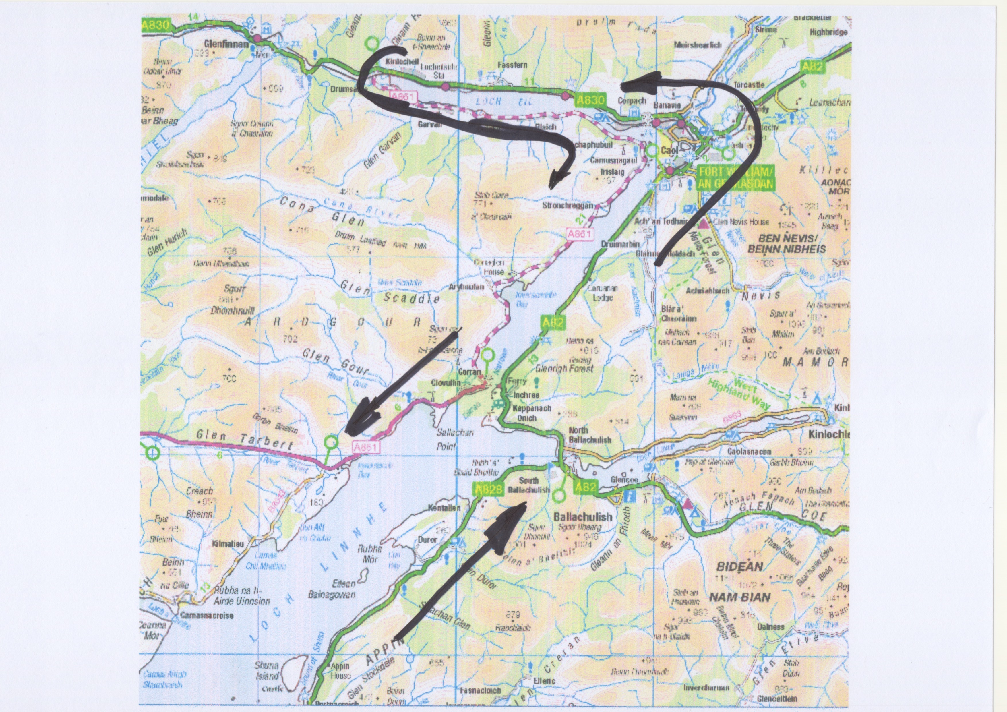
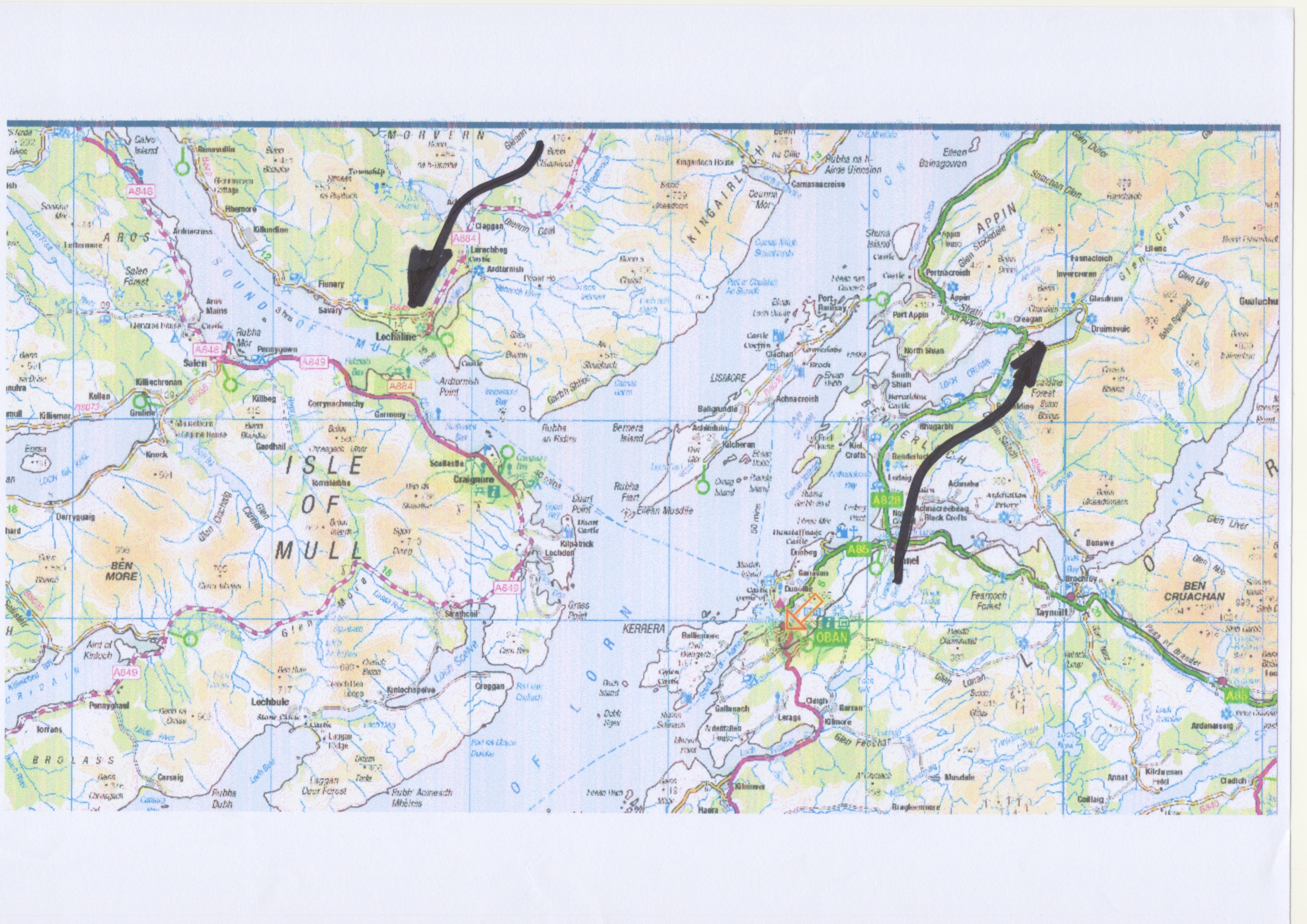


 It’s a bit of a slog, the journey taking 4 ½ to 5 hrs, so it’s snooze time and eating time and “looking out the window at dolphins” time. The aircraft style seats were very comfy.
 The island of Barra (at the bottom of the Outer Hebrides chain of islands) is not very large, only 18km long and 10km wide, at the most. There is one single-track road, the A888, which circles the island. At the village of Northbay is the spur road that goes north to the famous beach airport and the Ardmhor ferry terminal, which connects Barra to the isles of Eriskay and South Uist.
  So, out of the ferry terminal, I turned left/west, as I wanted to spot the campsite I’d chosen for 2022, but hadn’t gone to…… Along the way, I came across the Isle of Barra Beach Hotel, which looks rather nice – another time perhaps ???? Great location and fantastic views. Naturally, my selected campsite was at the furthest place away from any form of civilisation (see map above), right on the most northerly peninsular on the island at CROFT NUMBER 2 – literally at the end of the road…..


 After crossing the short causeway from the main island (one of many in the Outer Hebrides, as I was to find out later….) you are confronted by a wealth of beach “riches”. The East beach (Traigh a Bhaigh in Scottish Gaelic) is away from the direct influence of the Atlantic Ocean, whereas the West Beach (Traigh Shiar ) gets whatever weather is thrown at it. These are the two main beaches, but there are others. More to explore next time…..


 Bit of a slow start to the morning but then drive to the island of Grimsay. It has a circular main road loop from the main road and back, which makes it easy to “do”. The main attraction is the fishing port at Kallin (Ceallan in Gaelic), still very active by the looks of things. Unfortunately the place was a bit closed down on a Saturday, so the seafood shop/café was closed – no fresh fish for my supper…..


 The last time I was here in 2020 I tried to find a place called The Falls Of Kirkaig, following a recommendation from a fellow camper.


 I didn’t go to the complete edge of the ravine as I didn’t fancy spending time in the local casualty department. Non the less, extremely pretty location. Plenty of water flowing as well, so the fall itself was pretty impressive.


 After that it’s a trek across the dunes down to the beach itself. Yes ! This is the first REAL view you get of the bay


 After lunch, had a bit of a drive to the south of Applecross. It really is getting a bit at the end of the world-ish with villages/hamlets like Aird-Dhubh (Ard-Dhubh), Camustiel, Camusterrach and Toscaig. Along the way I saw quite a few small holdings with animals. There is a shop at Toscaig and a pier – that’s it ! Apparently, Toscaig once had a ferry service, linking to the Kyle of Lochhalsh which was the only route into Applecross when the road over the Bealach na Bà was closed. Now there is the road going north.


 However after about 30 minutes it suddenly gets a bit more rough, rocky and vertical. The path has been well repaired but using large stones/boulders and often big vertical steps/stairs – bit of a challenge for us oldies ! Good balance is NOT one of my specialities due to all my ear nonsense…..


 Note the date on the picture below – house still occupied in the 1930 !


 The siting of the castle is also pretty spectacular, being at the head of a loch. I guess it was also strategically placed as well.


 Not exactly extravagant port infrastructure, but that is the whole point ! A turntable ferry can operate using the very minimum of slipway in ALL states of the tide. Very clever design. The only obvious problem is that they are not exactly huge, but in their heyday the low levels of traffic were easily catered for.


 Then the turntable was manually rotated to point the right way for disembarking. I don’t apologise for the various video’s below – I was fascinated !